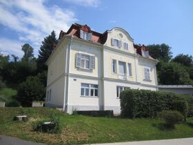
Blümelhofweg 10
Aus Baugeschichte
Österreich » Steiermark » Graz » 8044
Die Karte wird geladen …
{"format":"googlemaps3","type":"SATELLITE","minzoom":false,"maxzoom":false,"types":["ROADMAP","SATELLITE","HYBRID","TERRAIN"],"limit":800,"offset":0,"link":"all","sort":[""],"order":["random"],"headers":"show","mainlabel":"","intro":"","outro":"","searchlabel":"\u2026 weitere Ergebnisse","default":"","import-annotation":false,"width":"auto","height":"500px","centre":{"text":"","title":"","link":"","lat":47.1068599999999975125319906510412693023681640625,"lon":15.4853199999999997515942595782689750194549560546875,"icon":""},"title":"","label":"","icon":"","lines":[],"polygons":[],"circles":[],"rectangles":[],"copycoords":false,"static":false,"visitedicon":"","wmsoverlay":false,"zoom":18,"layers":[],"controls":["pan","zoom","type","scale","streetview","rotate"],"zoomstyle":"DEFAULT","typestyle":"DEFAULT","autoinfowindows":false,"resizable":false,"kmlrezoom":false,"poi":true,"cluster":false,"clustergridsize":60,"clustermaxzoom":20,"clusterzoomonclick":true,"clusteraveragecenter":true,"clusterminsize":2,"imageoverlays":[],"kml":[],"gkml":[],"searchmarkers":"","fullscreen":true,"mylocation":true,"mylocationfollow":false,"mylocationzoom":-1,"scrollwheelzoom":false,"showtitle":true,"hidenamespace":true,"template":"","userparam":"","activeicon":"","pagelabel":false,"ajaxcoordproperty":"Koordinaten","ajaxquery":"%5B%5BKategorie%3AListe_%28Adressen%29%5D%5D","locations":[{"text":"\u003Cdiv class=\"mw-parser-output\"\u003E\u003Cp\u003EBl\u00fcmelhofweg 10\n\u003C/p\u003E\u003C/div\u003E","title":"Bl\u00fcmelhofweg 10\n","link":"","lat":47.1068599999999975125319906510412693023681640625,"lon":15.4853199999999997515942595782689750194549560546875,"icon":"/images/b/b3/Info.png"},{"text":"\u003Cb\u003E\u003Ca href=\"/Mariatroster_Stra%C3%9Fe_281\" title=\"Mariatroster Stra\u00dfe 281\"\u003EMariatroster Stra\u00dfe 281\u003C/a\u003E\u003C/b\u003E","title":"Mariatroster Stra\u00dfe 281","link":"","lat":47.10581111110000307462541968561708927154541015625,"lon":15.4879583332999999356616172008216381072998046875,"icon":""},{"text":"\u003Cb\u003E\u003Ca href=\"/Bl%C3%BCmelhofweg_9\" title=\"Bl\u00fcmelhofweg 9\"\u003EBl\u00fcmelhofweg 9\u003C/a\u003E\u003C/b\u003E","title":"Bl\u00fcmelhofweg 9","link":"","lat":47.10719000000000278305378742516040802001953125,"lon":15.4839000000000002188471626141108572483062744140625,"icon":""},{"text":"\u003Cb\u003E\u003Ca href=\"/Himmelreichweg_80\" title=\"Himmelreichweg 80\"\u003EHimmelreichweg 80\u003C/a\u003E\u003C/b\u003E","title":"Himmelreichweg 80","link":"","lat":47.1078499999999991132426657713949680328369140625,"lon":15.486940000000000594582161284051835536956787109375,"icon":""},{"text":"\u003Cb\u003E\u003Ca href=\"/Bl%C3%BCmelhofweg_10\" title=\"Bl\u00fcmelhofweg 10\"\u003EBl\u00fcmelhofweg 10\u003C/a\u003E\u003C/b\u003E","title":"Bl\u00fcmelhofweg 10","link":"","lat":47.1068599999999975125319906510412693023681640625,"lon":15.4853199999999997515942595782689750194549560546875,"icon":""},{"text":"\u003Cb\u003E\u003Ca href=\"/Mariatroster_Stra%C3%9Fe_287\" title=\"Mariatroster Stra\u00dfe 287\"\u003EMariatroster Stra\u00dfe 287\u003C/a\u003E\u003C/b\u003E","title":"Mariatroster Stra\u00dfe 287","link":"","lat":47.1062416667000007919341442175209522247314453125,"lon":15.4879611111000006218318958417512476444244384765625,"icon":""}]}
47° 6' 24.70" N, 15° 29' 7.15" E
Der Blümelhof
Kommentare
Einzelnachweise
Cookies helfen uns bei der Bereitstellung von Baugeschichte. Durch die Nutzung von Baugeschichte erklärst du dich damit einverstanden, dass wir Cookies speichern.
